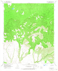
1966 Map of Sontag Creek
USGS Topo · Published 1968About this map
The high, ridged landscapes of the San Carlos Indian Reservation dominate this mid-1960s survey, revealing a territory defined by remote water sources and cattle-rearing infrastructure. The northern portion of the quadrangle is punctuated by essential ranching landmarks such as Gimme Tank, Walker Park Tank, and the high point at Dads Lookout. The terrain is deeply incised by Sontag Creek and Bear Canyon, where a localized industrial presence is marked by the Bear Canyon Mine and a nearby Borrow Pit. The southern flats contrast sharply with the northern ridges, featuring a dedicated Landing Strip and the expansive Blue River Pasture. This map illustrates how high-altitude springs, including Sontag Spring and Cienega Spring, served as the lifelines for both natural ecosystems and the managed grazing lands of Gila County during this era.
Find a feature on this map
35 named features on this map. Tap any name to fly to it.
Don’t see what you’re looking for? This feature index may not catch every label — zoom into the map to look around manually.
Map Details
Editions of this 1966 Sontag Creek Map
2 editions found
Other maps of this area

1954 · Mesa
USGS Topo · 1:250,000

1957 · Mesa
USGS Topo · 1:250,000

1958 · Mesa
USGS Topo · 1:250,000

1960 · Mesa
USGS Topo · 1:250,000

1964 · Mesa
USGS Topo · 1:250,000

1965 · Sontag Mesa
USGS Topo · 1:24,000

1966 · Brushy Canyon
USGS Topo · 1:24,000

1966 · Natural Corral
USGS Topo · 1:24,000
1966 · Bronco Gulch
USGS Topo · 1:24,000

1966 · Popcorn Canyon
USGS Topo · 1:24,000