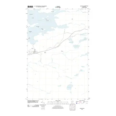
2010 Map of Soudan
USGS Topo · Published 2010About this map
Soudan Mine and the adjacent settlement of Soudan anchor this portion of the Iron Range, where the industrial legacy of northeastern Minnesota meets the sprawling waters of Vermilion Lake. The landscape is defined by a dense network of lakes and islands, including Birch Island, Timber Island, and the Seven Sisters Islands, indicating a terrain heavily shaped by glacial activity. Transport routes like Old Hwy 169 and Murray Rd connect the mine works to the small community of Murray and the Soudan Post Office. To the east, the topography transitions into a wilderness of smaller basins such as Sixmile Lake, Fourmile Lake, and Skeleton Lake. The presence of the LaRue Mine and the prominence of Jasper Peak reflect the geological significance of this district, while the Soudan Mine Overlook Rest Area suggests its modern role as a site for public history and observation.
Find a feature on this map
37 named features on this map. Tap any name to fly to it.
Don’t see what you’re looking for? This feature index may not catch every label — zoom into the map to look around manually.
Map Details
Editions of this 2010 Soudan Map
This is the sole edition of this map. No revisions or reprints were ever made.
Other maps of this area

1949 · Isaac Lake
USGS Topo · 1:24,000

1949 · Embarrass
USGS Topo · 1:24,000

1950 · Isaac Lake
USGS Topo · 1:24,000

1950 · Embarrass
USGS Topo · 1:24,000

1950 · Biwabik NE
USGS Topo · 1:24,000

1951 · Biwabik NE
USGS Topo · 1:24,000

1954 · Hibbing
USGS Topo · 1:250,000

1956 · Sioux Pine Island
USGS Topo · 1:24,000

1956 · Tower
USGS Topo · 1:24,000

1956 · Chad Lake
USGS Topo · 1:24,000