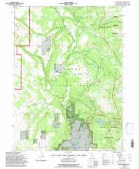
1993 Map of Soup Creek
USGS Topo · Published 1997About this map
Bowman Ranch and the lumber-related history of Cantrall Mill highlight the small-scale agricultural and industrial footprints within this high-country landscape. This 1990s revision of the Modoc National Forest shows a terrain defined by drainage systems like Fitzhugh Creek and the headwaters of Soup Creek. The map records a complex overlay of land management, including the State Game Refuge and the South Warner Wilderness, where the natural topography of Jess Valley and Bear Flat dictated early settlement patterns. Geologists and local historians can trace the hydrology from Soup Spring down to the dramatic drop at Mill Creek Falls near Clear Lake. These remote outposts and geographic features, such as Hacker Flat and Flournoy Swale, provide a clear picture of how early ranching and milling operations utilized the meadowlands and water sources of the Warner Mountains.
Find a feature on this map
43 named features on this map. Tap any name to fly to it.
Don’t see what you’re looking for? This feature index may not catch every label — zoom into the map to look around manually.
Map Details
Editions of this 1993 Soup Creek Map
This is the sole edition of this map. No revisions or reprints were ever made.
Other maps of this area

1886 · Alturas
USGS Topo · 1:250,000

1892 · Alturas
USGS Topo · 1:250,000

1954 · Alturas
USGS Topo · 1:250,000

1958 · Alturas
USGS Topo · 1:250,000

1962 · Alturas
USGS Topo · 1:250,000

1962 · Tule Mountain
USGS Topo · 1:24,000

1962 · Jess Valley
USGS Topo · 1:24,000
1962 · Emerson Peak
USGS Topo · 1:24,000

1963 · Warren Peak
USGS Topo · 1:24,000

1963 · Little Juniper Reservoir
USGS Topo · 1:24,000