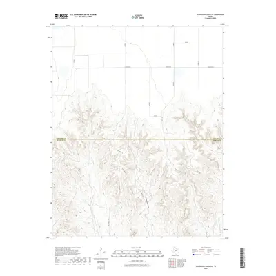
2019 Map of Sourdough Creek SW
USGS Topo · Published 2019About this map
Government Canyon dominates the southern half of this Texas Panhandle landscape, where deep erosional drainage patterns break the otherwise flat High Plains. The map highlights a stark transition between the rectilinear agricultural and ranching grid to the north and the complex, dissected terrain of the canyon system below. Local transportation routes like Mcgarraugh Rd and Wilson Rd descend into this complex topography, following the natural contours carved by seasonal watercourses such as W Dugout Cr and Hicks Cr. This survey captures the boundary between Ochiltree Co and Roberts Co, illustrating how the land use shifts from the open expanses along Ranch Rd 281 to the intricate network of breaks and draws that define the regional geography.
Find a feature on this map
14 named features on this map. Tap any name to fly to it.
Don’t see what you’re looking for? This feature index may not catch every label — zoom into the map to look around manually.
Map Details
Editions of this 2019 Sourdough Creek SW Map
This is the sole edition of this map. No revisions or reprints were ever made.
Other maps of this area

1954 · Perryton
USGS Topo · 1:250,000

1954 · Amarillo
USGS Topo · 1:250,000

1958 · Perryton
USGS Topo · 1:250,000

1958 · Amarillo
USGS Topo · 1:250,000

1971 · Dry Creek NE
USGS Topo · 1:24,000

1971 · Dry Creek North
USGS Topo · 1:24,000

1971 · Garden Springs
USGS Topo · 1:24,000

1973 · Sourdough Creek NE
USGS Topo · 1:24,000

1973 · Sourdough Creek SW
USGS Topo · 1:24,000

1973 · Spearman NE
USGS Topo · 1:24,000