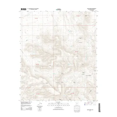
2013 Map of Souse Springs
USGS Topo · Published 2013About this map
Sierra de las Uvas dominates this desert landscape in Doña Ana County, defined by a complex network of canyons and high peaks. The terrain is marked by prominent landmarks such as Peloncillo Peak, Piña Peak, and the distinctive Tailholt Mtn. Water management is central to the area's geography, evidenced by numerous livestock tanks like Augustine Tank, Rattlesnake Tank, and S Kight Tank scattered across the high country. Natural water sources including Souse Springs and Las Uvas Spring provide critical points of interest within the arid environment. A series of county roads, including CO Road E004 and CO Road E002, navigate the gaps and draws, such as Big White Gap and Little White Gap, connecting this isolated range to the surrounding basin. The survey illustrates a specialized ranching landscape where every canyon, from Rodey Canyon to Broad Canyon, is named and utilized.
Find a feature on this map
48 named features on this map. Tap any name to fly to it.
Don’t see what you’re looking for? This feature index may not catch every label — zoom into the map to look around manually.
Map Details
Editions of this 2013 Souse Springs Map
This is the sole edition of this map. No revisions or reprints were ever made.
Other maps of this area

1943 · Corralitos Ranch
USGS Topo · 1:62,500

1955 · Las Cruces
USGS Topo · 1:250,000

1958 · Las Cruces
USGS Topo · 1:250,000

1958 · Arroyo Cuervo
USGS Topo · 1:24,000

1959 · Hatch
USGS Topo · 1:24,000
1959 · Sierra Alta
USGS Topo · 1:24,000
1959 · Souse Springs
USGS Topo · 1:24,000

1959 · Rincon
USGS Topo · 1:24,000

1961 · Nutt
USGS Topo · 1:62,500

1972 · Good Sight Peak NE
USGS Topo · 1:24,000