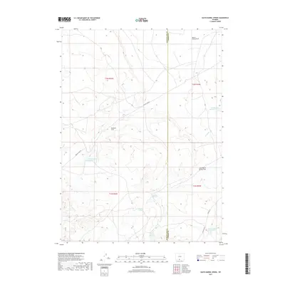
2017 Map of South Barrel Spring
USGS Topo · Published 2017About this map
The Sweetwater and Carbon County line bisects this 2017 survey, revealing a high-desert landscape defined by vital water infrastructure and drainage patterns. The hydrology of the region is centered on features like South Barrel Spring and Stratton Spring, which anchor a network of ephemeral watercourses including Barrel Springs Draw and South Barrel Springs Draw. To manage the scarce surface water in this arid environment, a series of man-made structures are evident, from the Dad Dail Reservoir to specialized water management points such as Detention Dam 1594 Number 3 and Mexican Flats Reservoir Number 1. A handful of established routes, notably Windmill Draw Rd and W Hangout Rd, provide the primary access through the grid-surveyed townships of this expansive rangeland.
Find a feature on this map
19 named features on this map. Tap any name to fly to it.
Don’t see what you’re looking for? This feature index may not catch every label — zoom into the map to look around manually.
Map Details
Editions of this 2017 South Barrel Spring Map
This is the sole edition of this map. No revisions or reprints were ever made.
Other maps of this area

1954 · Rawlins
USGS Topo · 1:250,000

1954 · Rock Springs
USGS Topo · 1:250,000

1958 · Rawlins
USGS Topo · 1:250,000

1958 · Rock Springs
USGS Topo · 1:250,000

1962 · Rawlins
USGS Topo · 1:250,000

1962 · Rock Springs
USGS Topo · 1:250,000

1967 · Rawlins
USGS Topo · 1:250,000

1970 · South Barrel Spring
USGS Topo · 1:24,000

1970 · Mexican Flats
USGS Topo · 1:24,000
1970 · Powder Mountain NE
USGS Topo · 1:24,000