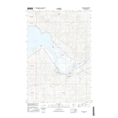
2017 Map of South Bend
USGS Topo · Published 2017About this map
South Bend occupies a sharp bend in the tidal waters where the Willapa River enters the broad expanse of Willapa Bay. The town's layout follows the shoreline, with streets like Water St and Robert Bush Dr hugging the riverfront, while residential blocks climb the hills toward the South Bend City Reservoir. This 2017 survey illustrates the complex geography of the Pacific Northwest coast, defined by an intricate network of marshes and waterways including Fredrickson Slough, Mailboat Slough, and Stony Slough. The maritime and industrial character of the region is evident in landmarks such as the Willapa Harbor Airport and Old Mill Pond, which sits just west of the downtown core. In the northern reaches, the terrain is shaped by numerous creek drainages like Smith Cr, Eagle Cr, and Clearwater Cr, while to the south, the North Fork Palix River and Bone River wind through the hills.
Find a feature on this map
62 named features on this map. Tap any name to fly to it.
Don’t see what you’re looking for? This feature index may not catch every label — zoom into the map to look around manually.
Map Details
Editions of this 2017 South Bend Map
This is the sole edition of this map. No revisions or reprints were ever made.
Other maps of this area

1938 · South Bend
USGS Topo · 1:62,500

1940 · Montesano
USGS Topo · 1:62,500

1940 · South Bend
USGS Topo · 1:62,500

1953 · Hoquiam
USGS Topo · 1:250,000

1955 · Montesano
USGS Topo · 1:62,500

1955 · Raymond
USGS Topo · 1:62,500
1955 · North Nemah
USGS Topo · 1:24,000

1955 · Aberdeen SE
USGS Topo · 1:24,000

1956 · Western
USGS Topo · 1:24,000

1957 · Hoquiam
USGS Topo · 1:250,000