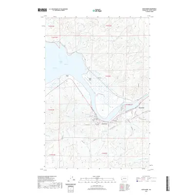
2020 Map of South Bend
USGS Topo · Published 2020About this map
South Bend and Raymond serve as the primary hubs on this Pacific County landscape, situated where the Willapa River meets Willapa Bay. The river's path through The Narrows emphasizes the area's historical reliance on tidal waterways for transport and industry, further evidenced by the presence of Old Mill Pond. As the county seat, South Bend is anchored by the Pacific County Courthouse and supported by infrastructure like the South Bend City Reservoir and Willapa Harbor Airport. This 2020 record of the region shows the conversion of former rail lines into the Willapa Hills State Park Trail, illustrating the shift from industrial timber transport to recreational use. Extensive sloughs, including Fredrickson Slough and Skidmore Slough, carve into the timbered hills, while local road names such as Odd Fellows Cemetery Rd and Smith Green House Rd provide specific points of interest for local history and genealogy research.
Find a feature on this map
62 named features on this map. Tap any name to fly to it.
Don’t see what you’re looking for? This feature index may not catch every label — zoom into the map to look around manually.
Map Details
Editions of this 2020 South Bend Map
This is the sole edition of this map. No revisions or reprints were ever made.
Other maps of this area

1938 · South Bend
USGS Topo · 1:62,500

1940 · Montesano
USGS Topo · 1:62,500

1940 · South Bend
USGS Topo · 1:62,500

1953 · Hoquiam
USGS Topo · 1:250,000

1955 · Montesano
USGS Topo · 1:62,500

1955 · Raymond
USGS Topo · 1:62,500
1955 · North Nemah
USGS Topo · 1:24,000

1955 · Aberdeen SE
USGS Topo · 1:24,000

1956 · Western
USGS Topo · 1:24,000

1957 · Hoquiam
USGS Topo · 1:250,000