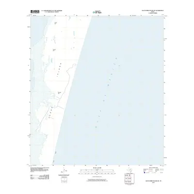
2010 Map of South Bird Island SE
USGS Topo · Published 2010About this map
Padre Island forms a thin, protective barrier between the mainland and the open waters of the Gulf of Mexico on this 2010 coastal survey. The terrain is defined by a series of distinct coastal elevations, including Green Hill, Dagger Hill, and Big Ball Hill, which serve as landmarks along this otherwise low-lying sandy stretch. Along the shoreline, Little Shell marks a specific coastal track or route, reflecting the island's isolation and its utility for those navigating the edge of the Texas coast. This survey by the U.S. Geological Survey emphasizes the natural topographic shift of the barrier island system before any significant modern development or alteration, focusing on the primary geological features and the rhythmic interface of land and sea.
Find a feature on this map
6 named features on this map. Tap any name to fly to it.
Don’t see what you’re looking for? This feature index may not catch every label — zoom into the map to look around manually.
Map Details
Editions of this 2010 South Bird Island SE Map
This is the sole edition of this map. No revisions or reprints were ever made.
Other maps of this area

1950 · Corpus Christi
USGS Topo · 1:250,000

1951 · South Bird Island
USGS Topo · 1:24,000

1951 · South Bird Island SE
USGS Topo · 1:24,000

1951 · South Bird Island NW
USGS Topo · 1:24,000

1951 · Point Of Rocks
USGS Topo · 1:24,000

1951 · South Bird Island
USGS Topo · 1:62,500

1952 · Yarborough Pass
USGS Topo · 1:24,000
1955 · Potrero Cortado
USGS Topo · 1:62,500

1956 · Corpus Christi
USGS Topo · 1:250,000

1960 · Corpus Christi
USGS Topo · 1:250,000