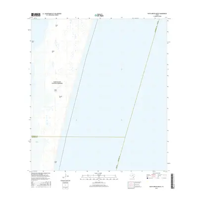
2016 Map of South Bird Island SE
USGS Topo · Published 2016About this map
Padre Island National Seashore dominates this coastal landscape, protecting a significant stretch of the Texas barrier island system. The terrain is defined by shifting coastal features, including sandy elevations such as Green Hill, Dagger Hill, and Big Ball Hill that rise above the surrounding wetlands. To the west, the Intracoastal Waterway serves as a critical navigation artery, separating the island from the mainland marshes. This 2016 survey captures the area’s complex hydrology, where the tidal influence is evident in features like Janes Hole and Boggy Slough. The boundary between Kleberg County and Kenedy County cuts across the southern portion of the sheet, marking a transition in local jurisdiction through this protected wilderness. The designation of Little Shell along the gulf side points to the natural depositional patterns characteristic of this undeveloped shoreline.
Find a feature on this map
12 named features on this map. Tap any name to fly to it.
Don’t see what you’re looking for? This feature index may not catch every label — zoom into the map to look around manually.
Map Details
Editions of this 2016 South Bird Island SE Map
This is the sole edition of this map. No revisions or reprints were ever made.
Other maps of this area

1950 · Corpus Christi
USGS Topo · 1:250,000

1951 · South Bird Island
USGS Topo · 1:24,000

1951 · South Bird Island SE
USGS Topo · 1:24,000

1951 · South Bird Island NW
USGS Topo · 1:24,000

1951 · Point Of Rocks
USGS Topo · 1:24,000

1951 · South Bird Island
USGS Topo · 1:62,500

1952 · Yarborough Pass
USGS Topo · 1:24,000
1955 · Potrero Cortado
USGS Topo · 1:62,500

1956 · Corpus Christi
USGS Topo · 1:250,000

1960 · Corpus Christi
USGS Topo · 1:250,000