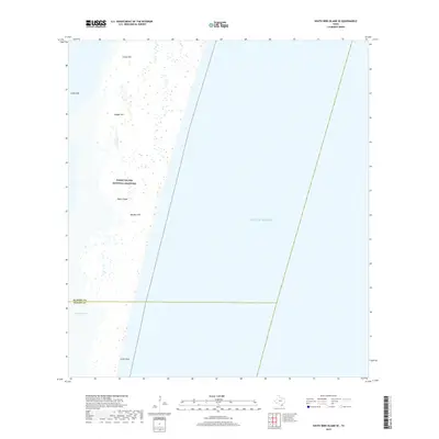
2019 Map of South Bird Island SE
USGS Topo · Published 2019About this map
Padre Island National Seashore dominates this coastal landscape, capturing the dynamic shifting sands of the Texas barrier island system. The terrain is defined by localized elevations and coastal features such as Green Hill, Dagger Hill, and Big Ball Hill, which rise above the surrounding tidal flats and dunes. To the west, the map details the intricate shoreline where the island meets the sheltered waters of Janes Hole and the inlet at Boggy Slough. The boundary between Kleberg County and Kenedy County cuts across the southern portion of the sheet, providing a precise marker for historical land records. Along the eastern edge, the open Gulf of Mexico meets the shore at Little Shell, a site known for its distinct beach character and shifting shoreline.
Find a feature on this map
10 named features on this map. Tap any name to fly to it.
Don’t see what you’re looking for? This feature index may not catch every label — zoom into the map to look around manually.
Map Details
Editions of this 2019 South Bird Island SE Map
This is the sole edition of this map. No revisions or reprints were ever made.
Other maps of this area

1950 · Corpus Christi
USGS Topo · 1:250,000

1951 · South Bird Island
USGS Topo · 1:24,000

1951 · South Bird Island SE
USGS Topo · 1:24,000

1951 · South Bird Island NW
USGS Topo · 1:24,000

1951 · Point Of Rocks
USGS Topo · 1:24,000

1951 · South Bird Island
USGS Topo · 1:62,500

1952 · Yarborough Pass
USGS Topo · 1:24,000
1955 · Potrero Cortado
USGS Topo · 1:62,500

1956 · Corpus Christi
USGS Topo · 1:250,000

1960 · Corpus Christi
USGS Topo · 1:250,000