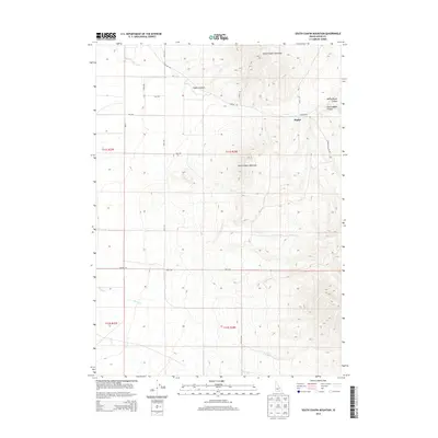
2013 Map of South Chapin Mountain
USGS Topo · Published 2013About this map
Heglar sits at the intersection of a network of local roads in this high-elevation corner of Cassia County. The landscape is defined by the significant prominence of South Chapin Mountain and North Chapin Mountain, which tower over the surrounding drainage systems. The map details the complex geography of the area's namesake canyon, specifically identifying North Heglar Canyon, South Heglar Canyon, and the main Heglar Canyon corridor. These rugged topographical features are primarily accessed via a grid of rural routes such as Heglar Rd and S Heglar Canyon Rd. Water sources in this arid environment are sparse, marked only by specific features like Butler Spring and the winding course of Shirley Cr in the southern portion of the quadrangle. The lack of dense settlement outside of the Heglar area highlights the isolated, high-country character of this part of southern Idaho.
Find a feature on this map
27 named features on this map. Tap any name to fly to it.
Don’t see what you’re looking for? This feature index may not catch every label — zoom into the map to look around manually.
Map Details
Editions of this 2013 South Chapin Mountain Map
This is the sole edition of this map. No revisions or reprints were ever made.
Other maps of this area

1954 · Pocatello
USGS Topo · 1:250,000

1958 · Pocatello
USGS Topo · 1:250,000

1958 · Sublett
USGS Topo · 1:62,500

1959 · Lake Walcott
USGS Topo · 1:62,500

1959 · Yale
USGS Topo · 1:62,500

1968 · Malta NE
USGS Topo · 1:24,000

1968 · Malta
USGS Topo · 1:24,000

1984 · North Chapin Mountain
USGS Topo · 1:24,000
1984 · Badger Peak
USGS Topo · 1:24,000
1984 · Lake Walcott SE
USGS Topo · 1:24,000