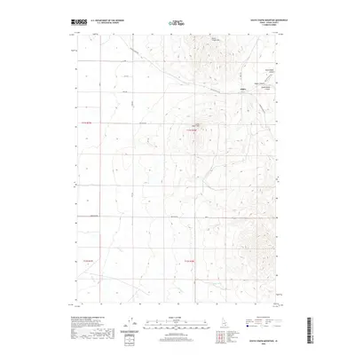
2020 Map of South Chapin Mountain
USGS Topo · Published 2020About this map
Heglar sits at the eastern edge of this high-altitude landscape in Cassia County, where the topography is defined by the significant peaks of North Chapin Mtn and South Chapin Mtn. This 2020 survey illustrates a remote ranching or mountain corridor shaped by several drainage systems, including Heglar Canyon, North Heglar Canyon, and South Heglar Canyon. The road network is primarily composed of section-line routes like 500 South Rd and 800 South Rd, which provide access to the drainages of Shirley Cr and Wagon Cr in the southern half of the map. Reliable water sources appear at isolated points such as Butler Spring, highlighting the arid character of this high basin environment. The map provides a clear look at the Public Land Survey System grid, including the intersection of townships T11S and T12S across ranges R27E and R28E.
Find a feature on this map
21 named features on this map. Tap any name to fly to it.
Don’t see what you’re looking for? This feature index may not catch every label — zoom into the map to look around manually.
Map Details
Editions of this 2020 South Chapin Mountain Map
This is the sole edition of this map. No revisions or reprints were ever made.
Other maps of this area

1954 · Pocatello
USGS Topo · 1:250,000

1958 · Pocatello
USGS Topo · 1:250,000

1958 · Sublett
USGS Topo · 1:62,500

1959 · Lake Walcott
USGS Topo · 1:62,500

1959 · Yale
USGS Topo · 1:62,500

1968 · Malta NE
USGS Topo · 1:24,000

1968 · Malta
USGS Topo · 1:24,000

1984 · North Chapin Mountain
USGS Topo · 1:24,000
1984 · Badger Peak
USGS Topo · 1:24,000
1984 · Lake Walcott SE
USGS Topo · 1:24,000