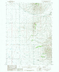
1985 Map of South Chapin Mountain
USGS Topo · Published 1985About this map
North Chapin Mountain and South Chapin Mountain dominate this mid-1980s landscape in Cassia County, defining a rugged drainage system characterized by deep canyons and seasonal water sources. The complex topography of Heglar Canyon is further divided into North Heglar Canyon and the truncated South Heglar Canyon, illustrating the intricate natural channeling of this high-elevation terrain. On the lower slopes and valley floors, Butler Spring and the headwaters of Shirley Creek and Warm Creek provide critical water points in an otherwise arid environment. A single Gravel Pit indicates local small-scale resource extraction, but the primary character of the map is one of remote, undeveloped land typical of southern Idaho's mountain ranges during the late 20th century.
Find a feature on this map
9 named features on this map. Tap any name to fly to it.
Don’t see what you’re looking for? This feature index may not catch every label — zoom into the map to look around manually.
Map Details
Editions of this 1985 South Chapin Mountain Map
This is the sole edition of this map. No revisions or reprints were ever made.
Other maps of this area

1954 · Pocatello
USGS Topo · 1:250,000

1958 · Pocatello
USGS Topo · 1:250,000

1958 · Sublett
USGS Topo · 1:62,500

1959 · Lake Walcott
USGS Topo · 1:62,500

1959 · Yale
USGS Topo · 1:62,500

1968 · Malta NE
USGS Topo · 1:24,000

1968 · Malta
USGS Topo · 1:24,000

1984 · North Chapin Mountain
USGS Topo · 1:24,000
1984 · Badger Peak
USGS Topo · 1:24,000
1984 · Lake Walcott SE
USGS Topo · 1:24,000