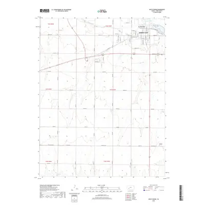
2018 Map of South Dodge
USGS Topo · Published 2018About this map
The Arkansas River flows through the northern reaches of this Ford County landscape, defining the southern edges of Dodge City and the neighboring community of South Dodge. This 2018 survey reveals a transition from the urban grid of the historic cattle town to the systematic section-line roads of the surrounding high plains. While the northern half of the quadrangle is dominated by residential development and streets like Longbranch Rd and Wilroads Garden Rd, the southern half is carved by the drainages of Mulberry Cr. Local history is anchored by the Christ the King Cem located near the intersection of Ford Ensign Rd and the highway. The map reflects a landscape deeply tied to its ranching roots, evidenced by evocative street names such as Outlaw Rd, Saddle Rd, and Quaker Rd that crisscross the agricultural territory south of the river valley.
Find a feature on this map
30 named features on this map. Tap any name to fly to it.
Don’t see what you’re looking for? This feature index may not catch every label — zoom into the map to look around manually.
Map Details
Editions of this 2018 South Dodge Map
This is the sole edition of this map. No revisions or reprints were ever made.
Other maps of this area

1892 · Dodge
USGS Topo · 1:125,000

1892 · Spearville
USGS Topo · 1:125,000

1894 · Spearville
USGS Topo · 1:125,000

1955 · Pratt
USGS Topo · 1:250,000

1955 · Dodge City
USGS Topo · 1:250,000

1958 · Dodge City
USGS Topo · 1:250,000

1959 · Pratt
USGS Topo · 1:250,000

1959 · Dodge City
USGS Topo · 1:250,000

1968 · Dodge City
USGS Topo · 1:24,000
1968 · Dodge City SW
USGS Topo · 1:24,000