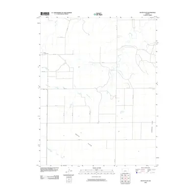
2009 Map of South Flats
USGS Topo · Published 2009About this map
South Flats and Harrison Flats dominate this High Plains landscape in western Wallace County, where the topography is defined by broad, level plateaus and the intermittent drainage systems that carve through them. The map reveals a strictly organized grid of rural routes, including Rd WA E-F and Rd WA S-22, which facilitate movement across the agricultural expanse. Water features are seasonal and subtle, represented by the meandering paths of Rose Creek, North Fork Rose Creek, and Sand Creek in the north, while Ladder Creek crosses the southwestern corner. One notable landmark of human activity in this otherwise sparse terrain is the Walker Landing Strip, situated in the northwest. This layout provides a clear view of the late 20th-century land management patterns, where isolated farmsteads are linked by a predictable network of gravel and dirt roads.
Find a feature on this map
24 named features on this map. Tap any name to fly to it.
Don’t see what you’re looking for? This feature index may not catch every label — zoom into the map to look around manually.
Map Details
Editions of this 2009 South Flats Map
This is the sole edition of this map. No revisions or reprints were ever made.
Other maps of this area

1955 · Scott City
USGS Topo · 1:250,000

1958 · Scott City
USGS Topo · 1:250,000

1959 · Weskan
USGS Topo · 1:62,500

1959 · Wallace
USGS Topo · 1:62,500

1968 · Sharon Springs 3 NE
USGS Topo · 1:24,000

1968 · Sharon Springs 4 NW
USGS Topo · 1:24,000

1968 · Sharon Springs 4 NE
USGS Topo · 1:24,000
1979 · Wallace
USGS Topo · 1:24,000
1979 · Sharon Springs West
USGS Topo · 1:24,000
1979 · Spring Valley Ranch
USGS Topo · 1:24,000