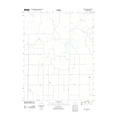
2012 Map of South Flats
USGS Topo · Published 2012About this map
Harrison Township in Wallace County is defined by its high plains landscape and a systematic grid of section roads that traverse the expansive plateaus known as Harrison Flats and South Flats. These flat uplands are deeply incised by the drainage systems of Rose Cr and its tributaries, including N Fork Rose Cr, alongside Sand Cr to the east. The 2012 topography shows a characteristic Western Kansas ranching environment where development is sparse and tied closely to the intermittent watercourses. Transport is managed through an organized network of rural routes such as Road WA S-22 and Road WA E-G, which facilitate movement across the open range and connect isolated structures dotting the landscape.
Find a feature on this map
13 named features on this map. Tap any name to fly to it.
Don’t see what you’re looking for? This feature index may not catch every label — zoom into the map to look around manually.
Map Details
Editions of this 2012 South Flats Map
This is the sole edition of this map. No revisions or reprints were ever made.
Other maps of this area

1955 · Scott City
USGS Topo · 1:250,000

1958 · Scott City
USGS Topo · 1:250,000

1959 · Weskan
USGS Topo · 1:62,500

1959 · Wallace
USGS Topo · 1:62,500

1968 · Sharon Springs 3 NE
USGS Topo · 1:24,000

1968 · Sharon Springs 4 NW
USGS Topo · 1:24,000

1968 · Sharon Springs 4 NE
USGS Topo · 1:24,000
1979 · Wallace
USGS Topo · 1:24,000
1979 · Sharon Springs West
USGS Topo · 1:24,000
1979 · Spring Valley Ranch
USGS Topo · 1:24,000