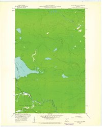
1960 Map of South Fowl Lake
USGS Topo · Published 1961About this map
South Fowl Lake and the Pigeon River define the international boundary at the start of the 1960s, a landscape where the wilderness of Grand Portage State Forest meets the Ontario-Minnesota border. This survey, coordinated by the State of Minnesota and the International Boundary Commission, documents the hydrography of the region in fine detail. The terrain is marked by a network of waterways including the Arrow River, Whitefish River, and North Fowl Lake, which flow through heavily forested elevations. Human presence is sparse, indicated only by a Gravel Pit and light-duty roads, while the natural character of the river systems is punctuated by designated Rapids and tributaries like Stump Brook and Portage Brook.
Find a feature on this map
13 named features on this map. Tap any name to fly to it.
Don’t see what you’re looking for? This feature index may not catch every label — zoom into the map to look around manually.
Map Details
Editions of this 1960 South Fowl Lake Map
4 editions found
Other maps of this area

1954 · Two Harbors
USGS Topo · 1:250,000

1957 · Two Harbors
USGS Topo · 1:250,000

1957 · Quetico
USGS Topo · 1:250,000

1958 · Two Harbors
USGS Topo · 1:250,000

1958 · Hancock
USGS Topo · 1:250,000

1959 · Mineral Center
USGS Topo · 1:24,000

1959 · Pine Lake East
USGS Topo · 1:24,000

1959 · Tom Lake
USGS Topo · 1:24,000

1959 · Fort William
USGS Topo · 1:250,000

1960 · Hancock
USGS Topo · 1:250,000