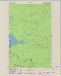
1960 Map of South Fowl Lake
USGS Topo · Published 1986About this map
South Fowl Lake and North Fowl Lake dominate the western portion of this border survey, marking the international boundary between the United States and Canada. This 1960s landscape, later revised in the 1980s, reveals the wild waterway network where the Pigeon River and Arrow River flow through the deep woods of the Superior National Forest and Grand Portage State Forest. The geography here is defined by hydraulic movement, featuring Whitefish River and Stump Brook, with noted Rapids indicating the challenging passage along the historic voyageur routes. A solitary Gravel Pit near the northern reaches of the Arrow River stands as one of the few signs of industrial activity in an area primarily dedicated to forest management and international boundary monitoring. Researchers can trace the precise contours of the Thunder Bay District and Cook County line as it follows the riverbed through these remote northwoods.
Find a feature on this map
14 named features on this map. Tap any name to fly to it.
Don’t see what you’re looking for? This feature index may not catch every label — zoom into the map to look around manually.
Map Details
Editions of this 1960 South Fowl Lake Map
4 editions found
Other maps of this area

1954 · Two Harbors
USGS Topo · 1:250,000

1957 · Two Harbors
USGS Topo · 1:250,000

1957 · Quetico
USGS Topo · 1:250,000

1958 · Two Harbors
USGS Topo · 1:250,000

1958 · Hancock
USGS Topo · 1:250,000

1959 · Mineral Center
USGS Topo · 1:24,000

1959 · Pine Lake East
USGS Topo · 1:24,000

1959 · Tom Lake
USGS Topo · 1:24,000

1959 · Fort William
USGS Topo · 1:250,000

1960 · Hancock
USGS Topo · 1:250,000