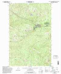
1992 Map of South Huckleberry Mtn.
USGS Topo · Published 1996About this map
Colville National Forest dominates this mountain landscape, defined by the drainage basins of Sherman Creek and its many tributaries. In the early 1990s, the terrain was characterized by a dense network of forest roads and land management features, including the Sherman Creek State Wildlife Recreation Area. The map reveals specific historical sites like Growden Camp, a location situated along the creek’s path through the forest. High points such as South Huckleberry Mountain and Dollar Mtn anchor the topography, while distinct ridges like Scalawag Ridge and Cedar Ridge separate the various watersheds. Natural water features are well-documented, from the secluded Sherman Lake to the waters of Lake Ellen at the edge of the survey area, showing the land as it was managed for both wildlife and resource extraction during this period.
Find a feature on this map
35 named features on this map. Tap any name to fly to it.
Don’t see what you’re looking for? This feature index may not catch every label — zoom into the map to look around manually.
Map Details
Editions of this 1992 South Huckleberry Mtn. Map
This is the sole edition of this map. No revisions or reprints were ever made.
Other maps of this area

1936 · Marcus
USGS Topo · 1:96,000

1942 · Marcus
USGS Topo · 1:125,000

1948 · Sherman Peak
USGS Topo · 1:62,500

1948 · Kettle Falls
USGS Topo · 1:62,500

1950 · Inchelium
USGS Topo · 1:62,500

1951 · Sherman Peak
USGS Topo · 1:62,500

1951 · Kettle Falls
USGS Topo · 1:62,500

1952 · Twin Lakes
USGS Topo · 1:62,500

1954 · Okanogan
USGS Topo · 1:250,000

1958 · Okanogan
USGS Topo · 1:250,000