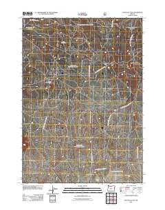
2011 Map of South Ice Cave
USGS Topo · Published 2011About this map
The cinder pits of Deschutes County anchor this high-desert landscape, reflecting the region's industrial and geologic history. Industrial activity at the South Ice Cave Cinder Pit and Lava Crossing Cinder Pit stands in contrast to the recreational access provided at the South Lava Trailhead. This 2011 survey reveals an intricate grid of forest access routes, primarily defined by thoroughfares like Natl Forest Develop Road 18 Rd and Natl Forest Develop Road 22 Rd. These roads facilitate movement through the volcanic terrain near Lava Pass, connecting remote industrial sites with the few natural water features like Pine Lake at the southern edge. The map provides a detailed look at the National Forest road system used by loggers, miners, and outdoorsmen in the early 21st century.
Find a feature on this map
13 named features on this map. Tap any name to fly to it.
Don’t see what you’re looking for? This feature index may not catch every label — zoom into the map to look around manually.
Map Details
Editions of this 2011 South Ice Cave Map
This is the sole edition of this map. No revisions or reprints were ever made.
Other maps of this area

1931 · Newberry Crater
USGS Topo · 1:125,000

1935 · Newberry Crater
USGS Topo · 1:125,000

1955 · Crescent
USGS Topo · 1:250,000

1957 · Crescent
USGS Topo · 1:250,000

1958 · Crescent
USGS Topo · 1:250,000

1970 · Crescent
USGS Topo · 1:250,000
1974 · Newberry Crater 4 NW
USGS Topo · 1:24,000

1979 · Crescent
USGS Topo · 1:100,000

1981 · Cougar Mtn
USGS Topo · 1:24,000
1981 · Cabin Lake
USGS Topo · 1:24,000