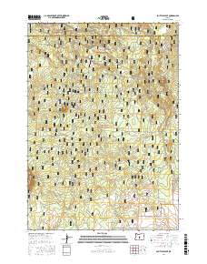
2017 Map of South Ice Cave
USGS Topo · Published 2017About this map
Deschutes National Forest land dominates this high-altitude landscape, where the volcanic heritage of Central Oregon is clearly visible through distinctive topographic forms. The southern portion of the Newberry Volcano caldera is the primary geographical influence, characterized by the rugged passage at Lava Pass and complex contouring that defines the local volcanic flow patterns. In the northern reaches of the map, the Deschutes Co and Lake Co boundary line cuts across a dense network of forest roads and off-highway vehicle trails, including Ohv #90 and Ohv #40. The presence of Pine Lake in the southern section provides a rare hydraulic feature in an otherwise arid, high-desert volcanic environment, marking a significant point of interest for those studying the regional geography of the Oregon backcountry.
Find a feature on this map
30 named features on this map. Tap any name to fly to it.
Don’t see what you’re looking for? This feature index may not catch every label — zoom into the map to look around manually.
Map Details
Editions of this 2017 South Ice Cave Map
This is the sole edition of this map. No revisions or reprints were ever made.
Other maps of this area

1931 · Newberry Crater
USGS Topo · 1:125,000

1935 · Newberry Crater
USGS Topo · 1:125,000

1955 · Crescent
USGS Topo · 1:250,000

1957 · Crescent
USGS Topo · 1:250,000

1958 · Crescent
USGS Topo · 1:250,000

1970 · Crescent
USGS Topo · 1:250,000
1974 · Newberry Crater 4 NW
USGS Topo · 1:24,000

1979 · Crescent
USGS Topo · 1:100,000

1981 · Cougar Mtn
USGS Topo · 1:24,000
1981 · Cabin Lake
USGS Topo · 1:24,000