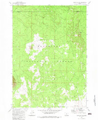
1982 Map of South Ice Cave
USGS Topo · Published 1983About this map
South Ice Cave and the volcanic terrain of the high desert define this 1982 survey along the border of Deschutes and Lake counties. The landscape is marked by the distinct geology of the Deschutes National Forest, featuring topographical landmarks such as Lava Pass and a series of extractive sites including the South Ice Cave Cinder Pit and Lava Crossing Cinder Pit. Water is a scarce and vital resource in this environment, represented here by Pine Lake and several isolated water points like B S Well and the East Pine Lake Well. The map illustrates a network of unimproved roads and four-wheel-drive tracks that navigate between lava flows and cinder cones, documenting the mid-century infrastructure used for forest management and local resource extraction.
Find a feature on this map
13 named features on this map. Tap any name to fly to it.
Don’t see what you’re looking for? This feature index may not catch every label — zoom into the map to look around manually.
Map Details
Editions of this 1982 South Ice Cave Map
This is the sole edition of this map. No revisions or reprints were ever made.
Other maps of this area

1931 · Newberry Crater
USGS Topo · 1:125,000

1935 · Newberry Crater
USGS Topo · 1:125,000

1955 · Crescent
USGS Topo · 1:250,000

1957 · Crescent
USGS Topo · 1:250,000

1958 · Crescent
USGS Topo · 1:250,000

1970 · Crescent
USGS Topo · 1:250,000
1974 · Newberry Crater 4 NW
USGS Topo · 1:24,000

1979 · Crescent
USGS Topo · 1:100,000

1981 · Cougar Mtn
USGS Topo · 1:24,000
1981 · Cabin Lake
USGS Topo · 1:24,000