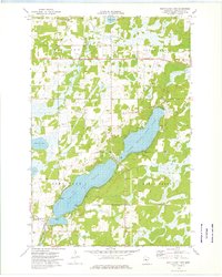
1973 Map of South Long Lake
USGS Topo · Published 1976About this map
South Long Lake and Upper South Long Lake dominate this Crow Wing County landscape, joined by a narrow channel that reflects the watery geography of central Minnesota. The 1973 topography reveals a rural pattern of development focused on the lakefronts and scattered agrarian institutions, including South Long Lake Church at the southern edge and the Vaale Cemetery to the north. The winding courses of the Nokay River and Nokasippi River drain the surrounding marshes and woodland areas, such as Maple Grove and Oak Lawn. Cultural sites like Bethel Church and its accompanying Bethel Cemetery provide specific points of interest for genealogists tracing local families. The presence of a prominent Pipeline and a Radio Facility near the Nokay River indicates the gradual integration of utility infrastructure into this lake-and-forest terrain during the early 1970s.
Find a feature on this map
20 named features on this map. Tap any name to fly to it.
Don’t see what you’re looking for? This feature index may not catch every label — zoom into the map to look around manually.
Map Details
Editions of this 1973 South Long Lake Map
This is the sole edition of this map. No revisions or reprints were ever made.
Other maps of this area

1912 · Deerwood
USGS Topo · 1:62,500

1914 · Deerwood
USGS Topo · 1:62,500

1915 · Brainerd
USGS Topo · 1:62,500

1918 · Brainerd
USGS Topo · 1:62,500

1948 · Lastrup
USGS Topo · 1:62,500

1950 · Lastrup
USGS Topo · 1:62,500

1953 · Duluth
USGS Topo · 1:250,000

1953 · Brainerd
USGS Topo · 1:250,000

1957 · Brainerd
USGS Topo · 1:250,000

1958 · Brainerd
USGS Topo · 1:250,000