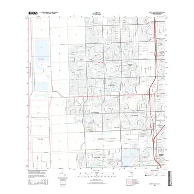
2015 Map of South Miami NW
USGS Topo · Published 2015About this map
Everglades National Park forms a distinct western boundary for the suburban sprawl of Miami-Dade County in this 2015 record. The landscape is defined by its sophisticated water management system, featuring an extensive network of canals such as the Black Creek Canal NO C-1W, Snapper Creek Canal NO C-2, and the Cutter Drain Canal NO C-100. These waterways weave through a series of master-planned communities including Kendale Lakes, The Hammocks, and The Crossings. The region's infrastructure is anchored by the Kendall-Tamiami Executive Airport and major healthcare facilities like Baptist Health Way. Numerous residential lakes, such as Winston Lake and San Sebastian Lake, are integrated into the modern residential developments, illustrating how the late-20th-century urban expansion adapted to the unique hydrology of the South Florida terrain.
Find a feature on this map
36 named features on this map. Tap any name to fly to it.
Don’t see what you’re looking for? This feature index may not catch every label — zoom into the map to look around manually.
Map Details
Editions of this 2015 South Miami NW Map
This is the sole edition of this map. No revisions or reprints were ever made.
Other maps of this area

1949 · South Miami NW
USGS Topo · 1:24,000

1949 · Goulds
USGS Topo · 1:24,000

1949 · Perrine
USGS Topo · 1:24,000

1950 · Hialeah
USGS Topo · 1:24,000

1950 · South Miami
USGS Topo · 1:24,000

1955 · South Miami NW
USGS Topo · 1:24,000

1956 · Goulds
USGS Topo · 1:24,000

1956 · Perrine
USGS Topo · 1:24,000

1956 · South Miami
USGS Topo · 1:24,000

1956 · Grossman Hammock
USGS Topo · 1:24,000