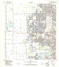
1988 Map of South Miami NW
USGS Topo · Published 1988About this map
Richmond Heights and the burgeoning planned community of The Hammocks define the suburban expansion of Miami-Dade County in the late 1980s. The landscape is a transition from the intensive agricultural and limestone extraction operations in the west, marked by numerous quarries and the U S Army Reservation, to the densely developed residential tracts and retail centers of the east. This era shows the integration of modern transit and aviation infrastructure, including the reach of the Metrorail and the expansive layout of Tamiami Airport with its associated Control Tower.
Find a feature on this map
79 named features on this map. Tap any name to fly to it.
Don’t see what you’re looking for? This feature index may not catch every label — zoom into the map to look around manually.
Map Details
Editions of this 1988 South Miami NW Map
This is the sole edition of this map. No revisions or reprints were ever made.
Other maps of this area

1949 · South Miami NW
USGS Topo · 1:24,000

1949 · Goulds
USGS Topo · 1:24,000

1949 · Perrine
USGS Topo · 1:24,000

1950 · Hialeah
USGS Topo · 1:24,000

1950 · South Miami
USGS Topo · 1:24,000

1955 · South Miami NW
USGS Topo · 1:24,000

1956 · Goulds
USGS Topo · 1:24,000

1956 · Perrine
USGS Topo · 1:24,000

1956 · South Miami
USGS Topo · 1:24,000

1956 · Grossman Hammock
USGS Topo · 1:24,000