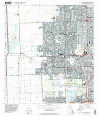
1994 Map of South Miami NW
USGS Topo · Published 2000About this map
The master-planned communities of The Hammocks and Westwood Lake define this western Miami-Dade landscape in the mid-1990s. The map illustrates a stark boundary where dense suburban expansion meets the protected wilderness of Everglades National Park along the western edge. Large-scale infrastructure anchors the southern portion of the sheet, including the expansive Tamiami Airport and several active quarries.
Find a feature on this map
65 named features on this map. Tap any name to fly to it.
Don’t see what you’re looking for? This feature index may not catch every label — zoom into the map to look around manually.
Map Details
Editions of this 1994 South Miami NW Map
This is the sole edition of this map. No revisions or reprints were ever made.
Other maps of this area

1949 · South Miami NW
USGS Topo · 1:24,000

1949 · Goulds
USGS Topo · 1:24,000

1949 · Perrine
USGS Topo · 1:24,000

1950 · Hialeah
USGS Topo · 1:24,000

1950 · South Miami
USGS Topo · 1:24,000

1955 · South Miami NW
USGS Topo · 1:24,000

1956 · Goulds
USGS Topo · 1:24,000

1956 · Perrine
USGS Topo · 1:24,000

1956 · South Miami
USGS Topo · 1:24,000

1956 · Grossman Hammock
USGS Topo · 1:24,000