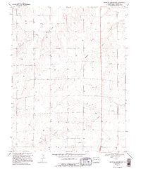
1970 Map of South of Burlington
USGS Topo · Published 1995About this map
Middle Beaver Creek and Sand Creek wind through this high plains landscape of Kit Carson County, illustrating the sparse but vital water networks of the Colorado grasslands. The terrain is defined by a series of shallow drainages and numerous Well sites, which represent the essential infrastructure of early 1970s ranching and agricultural operations. The extraction of local materials is evident in several Gravel Pits located in the western sections of the township. This survey, compiled from 1968 aerial photography, shows a strictly organized grid of sections and fence lines that underscore the methodical settlement and land use of the region. The map tracks the subtle shift of the land toward Sandy Creek in the south, providing a detailed record of the drainage patterns and land management techniques used during this era.
Find a feature on this map
10 named features on this map. Tap any name to fly to it.
Don’t see what you’re looking for? This feature index may not catch every label — zoom into the map to look around manually.
Map Details
Editions of this 1970 South of Burlington Map
This is the sole edition of this map. No revisions or reprints were ever made.
Other maps of this area

1954 · Limon
USGS Topo · 1:250,000

1957 · Limon
USGS Topo · 1:250,000

1958 · Limon
USGS Topo · 1:250,000

1969 · Mount Sunflower SW
USGS Topo · 1:24,000

1969 · Burlington 3 SE
USGS Topo · 1:24,000

1969 · Bethune
USGS Topo · 1:24,000

1969 · Burlington
USGS Topo · 1:24,000

1969 · Mount Sunflower NW
USGS Topo · 1:24,000

1969 · Peconic
USGS Topo · 1:24,000

1969 · Burlington 3 NW
USGS Topo · 1:24,000