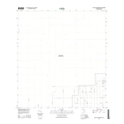
2015 Map of South of Coopertown
USGS Topo · Published 2015About this map
Everglades National Park dominates the western and central portions of this South of Coopertown landscape, illustrating the intentional preservation of the Florida wetlands. The map shows the stark division between the protected natural environment and the expanding rural-to-suburban grid of Miami-Dade County. To the east and south, a strictly geometric network of roads including SW 237th Ave and SW 120th St pushes against the park boundary, tracing the leading edge of land development in the mid-2010s. The presence of the Blue Shanty Canal in the northwest corner highlights the critical water management infrastructure necessary for this region's drainage and ecological balance. This survey captures a moment where agricultural blocks and residential street planning intersect with the massive, low-lying wilderness of the Florida Everglades.
Find a feature on this map
23 named features on this map. Tap any name to fly to it.
Don’t see what you’re looking for? This feature index may not catch every label — zoom into the map to look around manually.
Map Details
Editions of this 2015 South of Coopertown Map
This is the sole edition of this map. No revisions or reprints were ever made.
Other maps of this area

1949 · South Miami NW
USGS Topo · 1:24,000

1949 · Goulds
USGS Topo · 1:24,000

1955 · South Miami NW
USGS Topo · 1:24,000

1956 · Goulds
USGS Topo · 1:24,000

1956 · Grossman Hammock
USGS Topo · 1:24,000

1956 · Miami
USGS Topo · 1:250,000

1958 · Miami
USGS Topo · 1:250,000

1972 · Chekika Island
USGS Topo · 1:24,000

1972 · South Of Coopertown
USGS Topo · 1:24,000
1972 · Black Hammock
USGS Topo · 1:24,000