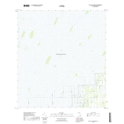
2018 Map of South of Coopertown
USGS Topo · Published 2018About this map
Everglades National Park dominates this landscape, showing the vast expanse of The Everglades where sawgrass marshes and tree islands stretch toward the horizon. The northwestern corner is defined by the Blue Shanty Canal, a linear hydrologic feature characteristic of South Florida's drainage and water management history. In the southeastern portion, the grid of the Miami-Dade County road system begins to encroach upon the natural wetlands. This transition zone illustrates the tension between urban expansion and conservation, where numbered routes like SW 136th St and SW 237th Ave terminate abruptly at the park boundary. The map provides a precise view of the various wetlands and hammocks that form the unique ecological fabric of this region before they give way to the agricultural and residential development found further east.
Find a feature on this map
22 named features on this map. Tap any name to fly to it.
Don’t see what you’re looking for? This feature index may not catch every label — zoom into the map to look around manually.
Map Details
Editions of this 2018 South of Coopertown Map
This is the sole edition of this map. No revisions or reprints were ever made.
Other maps of this area

1949 · South Miami NW
USGS Topo · 1:24,000

1949 · Goulds
USGS Topo · 1:24,000

1955 · South Miami NW
USGS Topo · 1:24,000

1956 · Goulds
USGS Topo · 1:24,000

1956 · Grossman Hammock
USGS Topo · 1:24,000

1956 · Miami
USGS Topo · 1:250,000

1958 · Miami
USGS Topo · 1:250,000

1972 · Chekika Island
USGS Topo · 1:24,000

1972 · South Of Coopertown
USGS Topo · 1:24,000
1972 · Black Hammock
USGS Topo · 1:24,000