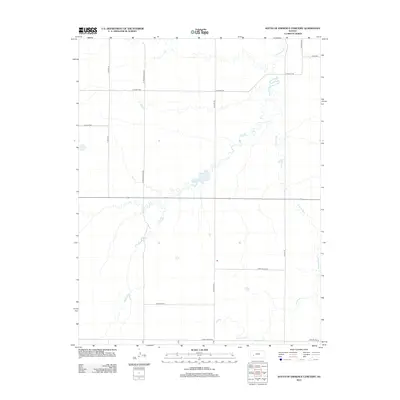
2012 Map of South of Eminence Cemetery
USGS Topo · Published 2012About this map
The Pawnee River meanders across this rural Finney County landscape, carving a serpentine path through the high plains of western Kansas. This 2012 survey shows an area dominated by agricultural large-lot partitioning, where the rigid grid of the Public Land Survey System is occasionally interrupted by the natural course of the water. Family and local history is etched into the landscape through names like Harry Oyler Rd and Linville Rd, which often indicate historical land ownership or early settlement routes. The southern boundary is defined by the Gray Co Line Rd and E Gray Co Line Rd, marking the transition between administrative territories. This map captures the modern connectivity of the region, anchored by the east-west corridor of Highway 156, while preserving the traditional naming conventions of the rural road network, including N Twin Springs Rd and N Clifton Rd.
Find a feature on this map
15 named features on this map. Tap any name to fly to it.
Don’t see what you’re looking for? This feature index may not catch every label — zoom into the map to look around manually.
Map Details
Editions of this 2012 South of Eminence Cemetery Map
This is the sole edition of this map. No revisions or reprints were ever made.
Other maps of this area

1892 · Dodge
USGS Topo · 1:125,000

1896 · Garden
USGS Topo · 1:125,000

1955 · Dodge City
USGS Topo · 1:250,000

1955 · Scott City
USGS Topo · 1:250,000

1958 · Dodge City
USGS Topo · 1:250,000

1958 · Scott City
USGS Topo · 1:250,000

1959 · Dodge City
USGS Topo · 1:250,000

1967 · Pierceville
USGS Topo · 1:24,000

1968 · Cimarron NW
USGS Topo · 1:24,000
1968 · Pierceville NE
USGS Topo · 1:24,000