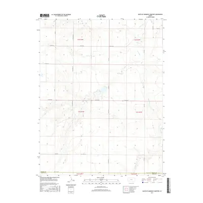
2015 Map of South of Eminence Cemetery
USGS Topo · Published 2015About this map
The Pawnee River meanders across this rural section of the High Plains, carving a distinct drainage pattern through the agricultural landscape of Finney and Gray counties. This 2015 survey illustrates the strict rectilinear geometry of the Public Land Survey System, where section lines are defined by gravel and dirt routes like N Twin Springs Rd and N Haflich Rd. The map reveals the persistence of the traditional township-and-range grid, with long-established corridors such as E Kansas Ave serving as primary east-west arteries. The absence of dense town sites highlights the vast, open character of this cattle and wheat country, where water sources and family-named roads like Algrim Rd and E Rockpit Rd remain the primary landmarks for local residents and land managers.
Find a feature on this map
22 named features on this map. Tap any name to fly to it.
Don’t see what you’re looking for? This feature index may not catch every label — zoom into the map to look around manually.
Map Details
Editions of this 2015 South of Eminence Cemetery Map
This is the sole edition of this map. No revisions or reprints were ever made.
Other maps of this area

1892 · Dodge
USGS Topo · 1:125,000

1896 · Garden
USGS Topo · 1:125,000

1955 · Dodge City
USGS Topo · 1:250,000

1955 · Scott City
USGS Topo · 1:250,000

1958 · Dodge City
USGS Topo · 1:250,000

1958 · Scott City
USGS Topo · 1:250,000

1959 · Dodge City
USGS Topo · 1:250,000

1967 · Pierceville
USGS Topo · 1:24,000

1968 · Cimarron NW
USGS Topo · 1:24,000
1968 · Pierceville NE
USGS Topo · 1:24,000