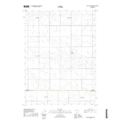
2017 Map of South of Gabe Rock
USGS Topo · Published 2017About this map
Rocky Hollow defines the central topography of this high-plains landscape where the boundary between Banner and Kimball Counties stretches across open rangeland. The map detail reflects the organized grid of the Public Land Survey System, with township and range lines such as t17n r56w anchoring the rural property divisions. A network of county roads, including Co Rd 14 and Co Rd 6, provides access to the isolated sections of this Western Nebraska terrain. The character of the land is shaped by the subtle drainages and ridges common to the region south of the Wildcat Hills, where infrastructure like the Kimball County Road serves as a primary east-west thoroughfare for the sparse ranching and agricultural operations scattered throughout the quadrangle.
Find a feature on this map
22 named features on this map. Tap any name to fly to it.
Don’t see what you’re looking for? This feature index may not catch every label — zoom into the map to look around manually.
Map Details
Editions of this 2017 South of Gabe Rock Map
This is the sole edition of this map. No revisions or reprints were ever made.
Other maps of this area

1898 · Scotts Bluff
USGS Topo · 1:125,000

1954 · Scottsbluff
USGS Topo · 1:250,000

1958 · Scottsbluff
USGS Topo · 1:250,000

1973 · Kimball 2 NE
USGS Topo · 1:24,000

1973 · Kimball 2 SE
USGS Topo · 1:24,000
1973 · Kimball 2 SW
USGS Topo · 1:24,000

1973 · Scotts Bluff 4 SW
USGS Topo · 1:24,000

1973 · Scotts Bluff 3 SE
USGS Topo · 1:24,000
1973 · Kimball 2 NW
USGS Topo · 1:24,000

1973 · Kimball 1 NW
USGS Topo · 1:24,000