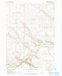
1969 Map of South Of Gordon
USGS Topo · Published 1993About this map
The Niobrara River carves through the southern half of this Sheridan County landscape, where the distinct topographical regions of West Gordon and East Gordon meet. In the late 1960s, this area remained a rural network of small school districts and isolated farm infrastructure, evidenced by the distribution of Valley Union Sch, Mount Hope Sch, and Prairie Plate Sch. These landmarks, along with the Mount Hope Cem, provide essential anchor points for genealogical research in this part of the Nebraska Sandhills.
Find a feature on this map
12 named features on this map. Tap any name to fly to it.
Don’t see what you’re looking for? This feature index may not catch every label — zoom into the map to look around manually.
Map Details
Editions of this 1969 South Of Gordon Map
2 editions found
Other maps of this area

1955 · Alliance
USGS Topo · 1:250,000

1957 · Alliance
USGS Topo · 1:250,000

1958 · Alliance
USGS Topo · 1:250,000

1969 · Rushville 4 SW
USGS Topo · 1:24,000

1969 · Gordon
USGS Topo · 1:24,000
1969 · Gordon SE
USGS Topo · 1:24,000

1969 · Clinton
USGS Topo · 1:24,000

1969 · Rushville SE
USGS Topo · 1:24,000
1969 · Rushville 4 NE
USGS Topo · 1:24,000
1969 · Rushville 4 NW
USGS Topo · 1:24,000