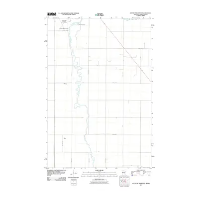
2011 Map of South of Wahpeton
USGS Topo · Published 2011About this map
The Bois de Sioux River meanders along the border of North Dakota and Minnesota, defining the western edge of this 2011 landscape. On the North Dakota side, small rural settlements such as Tyler and Elmore sit amidst a grid of section roads including 181 1/2 Ave SE and 182nd Ave SE. These small communities serve as local points of interest for genealogists and researchers tracking family histories in Richland County. The map also highlights significant local burial grounds such as Bohemian National Cemetery and Riverside Cemetery, located near the Breckenridge-Wahpeton Interstate Airport. In the northeastern corner, Breckenridge Lake and the confluence where the Rabbit River approaches the main waterway illustrate the flat, hydro-dominant geography of the Red River Valley region.
Find a feature on this map
16 named features on this map. Tap any name to fly to it.
Don’t see what you’re looking for? This feature index may not catch every label — zoom into the map to look around manually.
Map Details
Editions of this 2011 South of Wahpeton Map
This is the sole edition of this map. No revisions or reprints were ever made.
Other maps of this area

1904 · Wahpeton
USGS Topo · 1:125,000

1919 · Rothsay
USGS Topo · 1:62,500

1951 · Rothsay
USGS Topo · 1:62,500

1951 · Campbell
USGS Topo · 1:62,500

1953 · Fargo
USGS Topo · 1:250,000

1956 · Fargo
USGS Topo · 1:250,000

1964 · Fairmount NW
USGS Topo · 1:24,000

1964 · Dwight
USGS Topo · 1:24,000

1964 · Wahpeton
USGS Topo · 1:24,000
1972 · Sonora
USGS Topo · 1:24,000