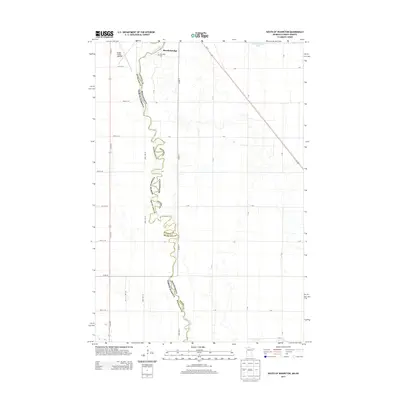
2013 Map of South of Wahpeton
USGS Topo · Published 2013About this map
The Red River meanders sharply along the border between North Dakota and Minnesota, carving a complex path between Richland Co and Wilkin Co. This 2013 survey illustrates the agricultural grid of the Red River Valley, where gravel roads like 11th St S and Co Hwy-9 service the fertile plains. At the northern edge of the map, the settlement of Breckenridge sits adjacent to the Riverside Cem, marking a point of historical and genealogical interest. The landscape is defined by its transition from the structured town plan to the expansive fields surrounding the Henry Stern Airport. To the east, Breckenridge Lake and the diagonal route of Us-75 provide key geographic markers in a region where the river remains the primary natural feature and jurisdictional boundary.
Find a feature on this map
34 named features on this map. Tap any name to fly to it.
Don’t see what you’re looking for? This feature index may not catch every label — zoom into the map to look around manually.
Map Details
Editions of this 2013 South of Wahpeton Map
This is the sole edition of this map. No revisions or reprints were ever made.
Other maps of this area

1904 · Wahpeton
USGS Topo · 1:125,000

1919 · Rothsay
USGS Topo · 1:62,500

1951 · Rothsay
USGS Topo · 1:62,500

1951 · Campbell
USGS Topo · 1:62,500

1953 · Fargo
USGS Topo · 1:250,000

1956 · Fargo
USGS Topo · 1:250,000

1964 · Fairmount NW
USGS Topo · 1:24,000

1964 · Dwight
USGS Topo · 1:24,000

1964 · Wahpeton
USGS Topo · 1:24,000
1972 · Sonora
USGS Topo · 1:24,000