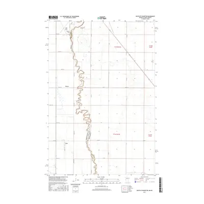
2016 Map of South of Wahpeton
USGS Topo · Published 2016About this map
The Bois de Sioux River forms a complex, winding border between North Dakota and Minnesota, defining the geography of Richland Co and Wilkin County. In this fertile Red River Valley landscape, the river’s tight meanders contrast with the rigid grid of rural roads like 182nd Ave SE and 400th St. To the north, the Harry Stern Airport and the Riverside Cem sit near the outskirts of the regional hub, while the Bohemian National Cem reflects the area's specific ethnic settlement patterns. Smaller localities such as Elmore and Tyler are situated along the section lines west of the river. The southern reach of the map shows the Rabbit River joining the main drainage, a critical junction in the local hydrology that historically influenced land use and farm placement in this prairie region.
Find a feature on this map
44 named features on this map. Tap any name to fly to it.
Don’t see what you’re looking for? This feature index may not catch every label — zoom into the map to look around manually.
Map Details
Editions of this 2016 South of Wahpeton Map
This is the sole edition of this map. No revisions or reprints were ever made.
Other maps of this area

1904 · Wahpeton
USGS Topo · 1:125,000

1919 · Rothsay
USGS Topo · 1:62,500

1951 · Rothsay
USGS Topo · 1:62,500

1951 · Campbell
USGS Topo · 1:62,500

1953 · Fargo
USGS Topo · 1:250,000

1956 · Fargo
USGS Topo · 1:250,000

1964 · Fairmount NW
USGS Topo · 1:24,000

1964 · Dwight
USGS Topo · 1:24,000

1964 · Wahpeton
USGS Topo · 1:24,000
1972 · Sonora
USGS Topo · 1:24,000