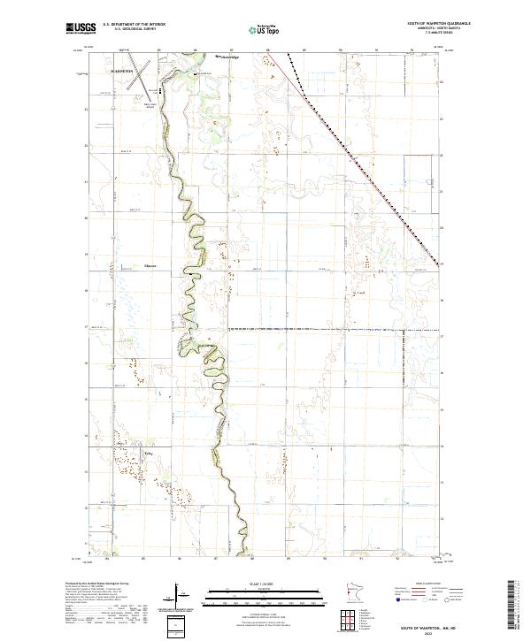
2022 Map of South of Wahpeton
USGS Topo · Published 2022About this map
The Bois de Sioux River defines the winding border between North Dakota and Minnesota in this 2022 survey, its serpentine channel cutting through the agricultural heart of the Red River Valley. At the northern edge of the map, the sister cities of Wahpeton and Breckenridge mark a significant regional center, where the Riverside Cem and Harry Stern Airport sit just west of the river. The landscape is structured by a rigorous grid of section lines and rural routes such as Co Hwy 110 and Co Hwy 6, supporting small settlements like Elmore and Tyler. This map captures the modern rural geography of Richland and Wilkin counties, illustrating how contemporary infrastructure follows the historical patterns of the prairie township system.
Find a feature on this map
28 named features on this map. Tap any name to fly to it.
Don’t see what you’re looking for? This feature index may not catch every label — zoom into the map to look around manually.
Map Details
Editions of this 2022 South of Wahpeton Map
This is the sole edition of this map. No revisions or reprints were ever made.
Other maps of this area

1904 · Wahpeton
USGS Topo · 1:125,000

1919 · Rothsay
USGS Topo · 1:62,500

1951 · Rothsay
USGS Topo · 1:62,500

1951 · Campbell
USGS Topo · 1:62,500

1953 · Fargo
USGS Topo · 1:250,000

1956 · Fargo
USGS Topo · 1:250,000

1964 · Fairmount NW
USGS Topo · 1:24,000

1964 · Dwight
USGS Topo · 1:24,000

1964 · Wahpeton
USGS Topo · 1:24,000
1972 · Sonora
USGS Topo · 1:24,000