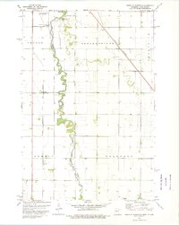
1973 Map of South of Wahpeton
USGS Topo · Published 1975About this map
The Bois De Sioux River meanders sharply through this landscape, defining the state boundary between North Dakota and Minnesota during the mid-1970s. This borderland region is dominated by an expansive agricultural grid, interspersed with critical transport infrastructure like the Chicago Milwaukee St Paul and Pacific railroad and the Burlington Northern line. The proximity of the Breckenridge Wahpeton Interstate Airport at the northern edge signals the area's role as a regional hub for the neighboring communities of Wilkin and Richland counties.
Find a feature on this map
21 named features on this map. Tap any name to fly to it.
Don’t see what you’re looking for? This feature index may not catch every label — zoom into the map to look around manually.
Map Details
Editions of this 1973 South of Wahpeton Map
This is the sole edition of this map. No revisions or reprints were ever made.
Other maps of this area

1904 · Wahpeton
USGS Topo · 1:125,000

1919 · Rothsay
USGS Topo · 1:62,500

1951 · Rothsay
USGS Topo · 1:62,500

1951 · Campbell
USGS Topo · 1:62,500

1953 · Fargo
USGS Topo · 1:250,000

1956 · Fargo
USGS Topo · 1:250,000

1964 · Fairmount NW
USGS Topo · 1:24,000

1964 · Dwight
USGS Topo · 1:24,000

1964 · Wahpeton
USGS Topo · 1:24,000
1972 · Sonora
USGS Topo · 1:24,000