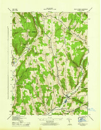
1944 Map of South Ostelic
USGS Topo · Published 1944About this map
South Otselic serves as the primary hub in this mid-1940s landscape, where the Otselic River and a unique State Fish Hatchery anchor the valley floor. The region is defined by a series of steep ridges and creek valleys, including South Hill and Silas Hill Mountain, which dictated the placement of small upland hamlets like Mariposa and Rhode Island.
Find a feature on this map
57 named features on this map. Tap any name to fly to it.
Don’t see what you’re looking for? This feature index may not catch every label — zoom into the map to look around manually.
Map Details
Editions of this 1944 South Ostelic Map
This is the sole edition of this map. No revisions or reprints were ever made.
Other maps of this area

1897 · Cazenovia
USGS Topo · 1:62,500

1899 · Cazenovia
USGS Topo · 1:62,500

1902 · Morrisville
USGS Topo · 1:62,500

1903 · Norwich
USGS Topo · 1:62,500

1904 · Pitcher
USGS Topo · 1:62,500

1943 · Otselic
USGS Topo · 1:24,000

1943 · De Ruyter
USGS Topo · 1:24,000

1943 · West Eaton
USGS Topo · 1:24,000

1943 · South Ostelic
USGS Topo · 1:24,000

1943 · Cincinnatus
USGS Topo · 1:24,000