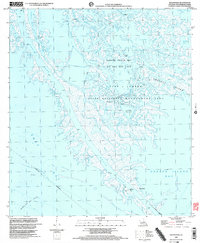
1998 Map of South Pass
USGS Topo · Published 2003About this map
Port Eads anchors the southern tip of this coastal survey, situated where South Pass meets the Gulf waters near the East Jetty. The landscape is a complex network of active distributaries, including Dennis Pass, Cadro Pass, and Pass A Loutre, reflecting the dynamic deltaic environment of the late 20th century. Extensive industrial infrastructure is integrated into the marshlands, notably the large Oil and Gas Field and Block 27 Oil Field, supported by a web of pipelines and canals. Much of the central terrain is dedicated to the State Waterfowl Management Area, preserving vital habitat amidst the region's energy production. Named features like Loomis Pond and Sawdust Bend Bayou trace the intricate hydrology of the area, while the Waste Water Disposal Area and Sludge Pits highlight the operational footprint of the offshore and coastal petroleum industry during this era.
Find a feature on this map
37 named features on this map. Tap any name to fly to it.
Don’t see what you’re looking for? This feature index may not catch every label — zoom into the map to look around manually.
Map Details
Editions of this 1998 South Pass Map
This is the sole edition of this map. No revisions or reprints were ever made.
Other maps of this area

1893 · East Delta
USGS Topo · 1:62,500

1893 · West Delta
USGS Topo · 1:62,500

1935 · Garden Island Pass
USGS Topo · 1:31,680

1935 · South Pass
USGS Topo · 1:31,680

1946 · Mudpan Bayou
USGS Topo · 1:31,680

1947 · Garden Island Pass
USGS Topo · 1:31,680

1947 · Pass A Loutre West
USGS Topo · 1:31,680

1947 · Southwest Pass
USGS Topo · 1:31,680

1947 · Pass A Loutre East
USGS Topo · 1:31,680

1949 · Cubits Gap
USGS Topo · 1:31,680