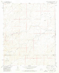
1978 Map of South Taylor Tank
USGS Topo · Published 1979About this map
The Lincoln National Forest boundary marks the southern portion of this high-desert terrain, where the landscape is defined by an intricate network of dry washes and canyons. Published in the late 1970s, this survey captures a remote section of the border between Chaves and Otero counties, a region primarily used for ranching and resource extraction. The presence of numerous water catchments like Collier Tank, Holt Tank, and South Taylor Tank underscores the importance of water management in this arid environment, providing essential points of interest for those tracking historical land use.
Find a feature on this map
18 named features on this map. Tap any name to fly to it.
Don’t see what you’re looking for? This feature index may not catch every label — zoom into the map to look around manually.
Map Details
Editions of this 1978 South Taylor Tank Map
This is the sole edition of this map. No revisions or reprints were ever made.
Other maps of this area

1943 · Texas Hill
USGS Topo · 1:62,500

1945 · Texas Hill
USGS Topo · 1:62,500

1954 · Carlsbad
USGS Topo · 1:250,000

1958 · Carlsbad
USGS Topo · 1:250,000

1963 · Panama Ranch
USGS Topo · 1:24,000

1965 · Lewis Peak NE
USGS Topo · 1:24,000

1965 · Bullis Spring Ranch
USGS Topo · 1:24,000

1978 · Strychnine Draw
USGS Topo · 1:24,000

1978 · Encino Draw
USGS Topo · 1:24,000

1978 · Artesia
USGS Topo · 1:100,000