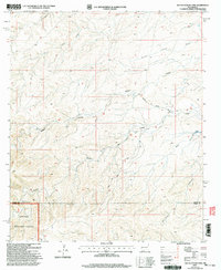
2001 Map of South Taylor Tank
USGS Topo · Published 2003About this map
Lincoln National Forest land meets the high-desert drainages of southeastern New Mexico in this detailed Forest Service revision. The landscape is defined by a series of named canyons and draws, including Sargent Canyon, Crooked Canyon, and Bear Draw, which channel seasonal water toward the southern boundary of Chaves and Otero counties. This arid environment required a sophisticated network of water management features, evidenced by labels for South Taylor Tank, Holt Tank, and the Crooked Water Storage Tank. These tanks and isolated wells supported ranching operations and forest management across the rugged topography. Primitive transportation routes like Bronc Road and Buck Road provide the primary access through the canyon systems, while a Gravel Pit near the center of the sheet indicates localized resource extraction during the early 21st century.
Find a feature on this map
22 named features on this map. Tap any name to fly to it.
Don’t see what you’re looking for? This feature index may not catch every label — zoom into the map to look around manually.
Map Details
Editions of this 2001 South Taylor Tank Map
This is the sole edition of this map. No revisions or reprints were ever made.
Other maps of this area

1943 · Texas Hill
USGS Topo · 1:62,500

1945 · Texas Hill
USGS Topo · 1:62,500

1954 · Carlsbad
USGS Topo · 1:250,000

1958 · Carlsbad
USGS Topo · 1:250,000

1963 · Panama Ranch
USGS Topo · 1:24,000

1965 · Lewis Peak NE
USGS Topo · 1:24,000

1965 · Bullis Spring Ranch
USGS Topo · 1:24,000

1978 · Strychnine Draw
USGS Topo · 1:24,000

1978 · Encino Draw
USGS Topo · 1:24,000

1978 · Artesia
USGS Topo · 1:100,000