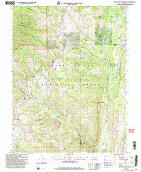
2001 Map of South Tent Mountain
USGS Topo · Published 2004About this map
Skyline Drive traverses the high ridge of the Wasatch Plateau, following the spine of the Manti-La Sal National Forest during this 2001 revision. The landscape is defined by its complex water management and topographic extremes, from the high summits of South Tent Mountain and North Tent Mountain to the depths of Potters Canyon. Traces of early engineering and agricultural efforts are visible in the network of irrigation and water transport features, such as the Potters Canyon Ditch, the Cedar Creek Tunnel, and the Mountain Tunnel.
Find a feature on this map
47 named features on this map. Tap any name to fly to it.
Don’t see what you’re looking for? This feature index may not catch every label — zoom into the map to look around manually.
Map Details
Editions of this 2001 South Tent Mountain Map
This is the sole edition of this map. No revisions or reprints were ever made.
Other maps of this area

1885 · Manti
USGS Topo · 1:250,000

1895 · Manti
USGS Topo · 1:250,000

1923 · Scofield
USGS Topo · 1:62,500

1923 · Hiawatha
USGS Topo · 1:62,500

1925 · Scofield
USGS Topo · 1:62,500

1925 · Hiawatha
USGS Topo · 1:62,500

1956 · Price
USGS Topo · 1:250,000

1960 · Price
USGS Topo · 1:250,000

1962 · Price
USGS Topo · 1:250,000

1965 · Huntington Reservoir
USGS Topo · 1:24,000