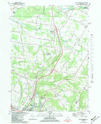
1983 Map of South Trenton
USGS Topo · Published 1983About this map
South Trenton and North Gage anchor this 1983 landscape north of Utica, where the rural hills of Trenton and Deerfield meet the expanding commercial fringes of the city. The map captures a moment of transition, showing traditional agricultural landmarks like the Sandpit and Cameron Hill alongside modern mid-century developments. Near the southern edge, the rise of regional commerce is evident at Horatio Mall and Riverside Mall, while the Drive-in Theater and Broadacres Nursing Home mark the evolving social geography of the post-war era.
Find a feature on this map
49 named features on this map. Tap any name to fly to it.
Don’t see what you’re looking for? This feature index may not catch every label — zoom into the map to look around manually.
Map Details
Editions of this 1983 South Trenton Map
This is the sole edition of this map. No revisions or reprints were ever made.
Other maps of this area

1895 · Oriskany
USGS Topo · 1:62,500

1897 · Remsen
USGS Topo · 1:62,500

1898 · Utica
USGS Topo · 1:62,500

1898 · Oriskany
USGS Topo · 1:62,500

1900 · Utica
USGS Topo · 1:62,500

1900 · Remsen
USGS Topo · 1:62,500

1904 · Boonville
USGS Topo · 1:62,500

1943 · Newport
USGS Topo · 1:24,000

1943 · Utica East
USGS Topo · 1:24,000
1943 · Ilion
USGS Topo · 1:24,000