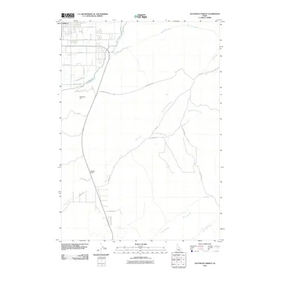
2010 Map of Southeast Emmett
USGS Topo · Published 2010About this map
Emmett sits at the northwestern edge of this landscape, where the residential grid gives way to a complex system of irrigation and natural drainage. The area is defined by its water management, including the Black Canyon Canal and Last Chance Canal, which navigate the elevation changes near Freezeout Hill. This terrain is deeply etched by a network of seasonal watercourses like Sand Hollow Creek and Willow Creek, carving out named features such as Jackass Gulch.
Find a feature on this map
29 named features on this map. Tap any name to fly to it.
Don’t see what you’re looking for? This feature index may not catch every label — zoom into the map to look around manually.
Map Details
Editions of this 2010 Southeast Emmett Map
This is the sole edition of this map. No revisions or reprints were ever made.
Other maps of this area

1892 · Boise
USGS Topo · 1:125,000

1897 · Boise
USGS Topo · 1:125,000

1898 · Nampa
USGS Topo · 1:125,000

1953 · Eagle
USGS Topo · 1:24,000

1953 · Star
USGS Topo · 1:24,000

1953 · Montour
USGS Topo · 1:62,500

1955 · Boise
USGS Topo · 1:250,000

1958 · Boise
USGS Topo · 1:250,000
1958 · Middleton
USGS Topo · 1:24,000

1962 · Boise
USGS Topo · 1:250,000