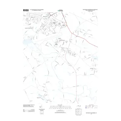
2013 Map of Southeast Goldsboro
USGS Topo · Published 2013About this map
Seymour Johnson Air Force Base dominates the northern landscape of this region, shaping the suburban expansion of Wayne County. The residential developments of Seymour Johnson Homes and Berkeley Village are situated adjacent to the military installation, reflecting the post-war growth of the community. To the south, the meandering Neuse River provides a natural boundary, separating the structured street grids of neighborhoods like Webtown and Adamsville from the more rural drainage basins of Sleepy Creek and Cabin Br. Near the southern edge of the quadrangle, Camp Carver sits near the creek, while small named enclaves like Irongate and Sandy Springs illustrate the modern residential infill between the air base and the surrounding farmland and river bottomlands.
Find a feature on this map
225 named features on this map. Tap any name to fly to it.
Don’t see what you’re looking for? This feature index may not catch every label — zoom into the map to look around manually.
Map Details
Editions of this 2013 Southeast Goldsboro Map
This is the sole edition of this map. No revisions or reprints were ever made.
Other maps of this area

1953 · Rocky Mount
USGS Topo · 1:250,000

1953 · Raleigh
USGS Topo · 1:250,000

1954 · Rocky Mount
USGS Topo · 1:250,000

1954 · Raleigh
USGS Topo · 1:250,000

1957 · Goldsboro
USGS Topo · 1:62,500

1957 · Seven Springs
USGS Topo · 1:62,500

1974 · Northwest Goldsboro
USGS Topo · 1:24,000

1974 · Southwest Goldsboro
USGS Topo · 1:24,000
1977 · Mount Olive
USGS Topo · 1:24,000

1980 · Seven Springs
USGS Topo · 1:24,000