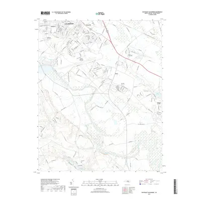
2019 Map of Southeast Goldsboro
USGS Topo · Published 2019About this map
Seymour Johnson Air Force Base dominates the central landscape of this 2019 survey, anchoring the area between the city of Goldsboro and the winding course of the Neuse River. The map captures a transition from the urban grid of Webtown and Adamsville to the rural expanses of southeastern Wayne County, where legacy landforms like the Walnut Pocosin and Bogue Marsh persist alongside modern residential developments. Genealogists and local historians can trace several significant burial grounds, including the Eastern Carolina State Veterans Cem and the older New Hope Friends Cem. The drainage patterns defined by Stoney Cr and Walnut Cr dictate the local geography, leading toward the incorporated village of Walnut Creek and the managed waters of Sleepy Creek Lake Upper.
Find a feature on this map
187 named features on this map. Tap any name to fly to it.
Don’t see what you’re looking for? This feature index may not catch every label — zoom into the map to look around manually.
Map Details
Editions of this 2019 Southeast Goldsboro Map
This is the sole edition of this map. No revisions or reprints were ever made.
Other maps of this area

1953 · Rocky Mount
USGS Topo · 1:250,000

1953 · Raleigh
USGS Topo · 1:250,000

1954 · Rocky Mount
USGS Topo · 1:250,000

1954 · Raleigh
USGS Topo · 1:250,000

1957 · Goldsboro
USGS Topo · 1:62,500

1957 · Seven Springs
USGS Topo · 1:62,500

1974 · Northwest Goldsboro
USGS Topo · 1:24,000

1974 · Southwest Goldsboro
USGS Topo · 1:24,000
1977 · Mount Olive
USGS Topo · 1:24,000

1980 · Seven Springs
USGS Topo · 1:24,000