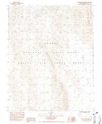
1983 Map of Southeastern Mine
USGS Topo · Published 1983About this map
The Southeastern Mine sits as a lonely industrial anchor in a landscape defined by the overlapping boundaries of high-desert conservation and military activity. Situated within the Desert National Wildlife Range, this 1983 provisional survey highlights the stark geography where the Pintwater Range and Desert Range converge. Much of the southern and western territory is occupied by the Nellis Air Force Range, a restricted area that has long dominated the local land use of southern Lincoln County. The map details the transition from the steep, arid slopes of the ranges down into the broad expanse of Three Lakes Valley. This document, based on 1970s field data, captures the intersection of mining history and modern federal management in a region where few permanent settlements ever took hold.
Find a feature on this map
7 named features on this map. Tap any name to fly to it.
Don’t see what you’re looking for? This feature index may not catch every label — zoom into the map to look around manually.
Map Details
Editions of this 1983 Southeastern Mine Map
This is the sole edition of this map. No revisions or reprints were ever made.
Other maps of this area

1907 · Las Vegas
USGS Topo · 1:250,000

1908 · Las Vegas
USGS Topo · 1:250,000

1942 · Emigrant Valley
USGS Topo · 1:125,000

1942 · Indian Spring
USGS Topo · 1:125,000

1945 · Sheep Range
USGS Topo · 1:125,000

1945 · Alamo
USGS Topo · 1:125,000

1954 · Caliente
USGS Topo · 1:250,000

1954 · Las Vegas
USGS Topo · 1:250,000

1957 · Las Vegas
USGS Topo · 1:250,000

1959 · Caliente
USGS Topo · 1:250,000