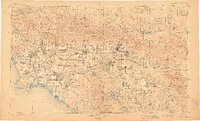
1904 Map of Southern California Sheet No. 1
USGS Topo · Published 1907About this map
Los Angeles and its surrounding valleys at the start of the twentieth century appear here as a network of young citrus-belt towns and budding coastal developments. This regional overview, compiled from early surveys between 1893 and 1900, shows the inland reach of the Pacific Electric Ry. and the Southern Pacific R. R. as they spurred growth toward San Bernardino and Riverside. The landscape is defined by massive federal holdings like the San Gabriel Timber Land Reserve and several early tribal territories, including the Coahuila Indian Reservation. Along the coast, San Pedro Bay and Newport Bay reveal the maritime character of the shoreline before modern industrial harbor transformations. To the east, the map traces critical transit corridors through the Cajon Pass and San Gorgonio Pass, highlighting the geographical bottlenecks that shaped California's southern expansion.
Find a feature on this map
105 named features on this map. Tap any name to fly to it.
Don’t see what you’re looking for? This feature index may not catch every label — zoom into the map to look around manually.
Map Details
Editions of this 1904 Southern California Sheet No. 1 Map
2 editions found

Other maps of this area

1894 · Los Angeles
USGS Topo · 1:62,500

1894 · Pomona
USGS Topo · 1:62,500

1896 · Santa Ana
USGS Topo · 1:62,500

1896 · Pasadena
USGS Topo · 1:62,500

1896 · Anaheim
USGS Topo · 1:62,500

1896 · Redondo
USGS Topo · 1:62,500

1896 · San Bernardino
USGS Topo · 1:62,500

1896 · Las Bolsas
USGS Topo · 1:62,500

1896 · Santa Monica
USGS Topo · 1:62,500

1896 · San Pedro
USGS Topo · 1:62,500